hackmatack trail racing
share the fun stuff.. .  .   .    .     .
  • Home
  • Herring Run 10/20k
  • Rompin Rockwood 10k/25k/50k
  • Results
    • Herring Run Results >
      • 2022 HR
      • 2021 HR
      • 2020 cancelled for COVID
      • 2019 HR
      • 2018 HR
      • 2017 HR
      • 2016 HR
      • 2015 HR
      • 2014 HR
      • 2013 HR
    • Rompin Rockwood Results >
      • RR 2018
      • 2017 RR
      • 2016 RR
  • Trail maps
  • Contact / About
  • Other races worth doing
  • Blog

Icebug shoes

1/10/2014

2 Comments

 
Picture
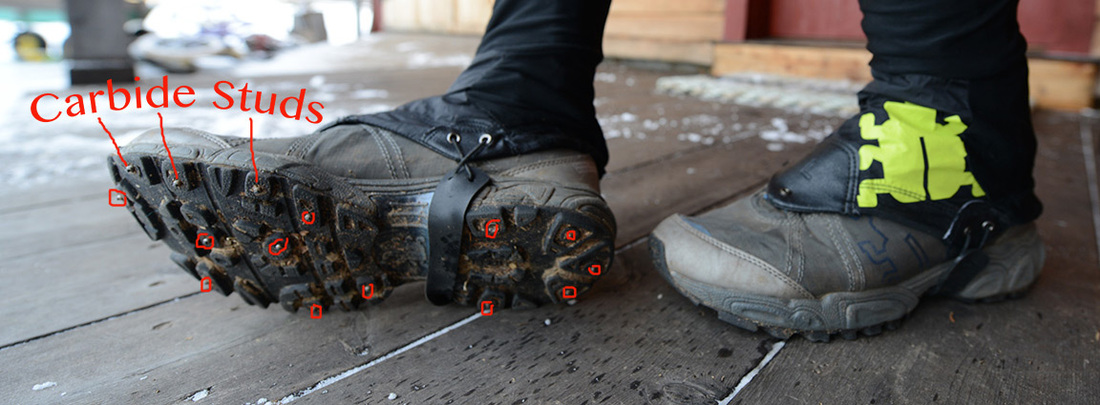
      These Icebug Hero carbide studded trail running shoes have been absolutely essential for me to train all winter long, especially with the crazy snow-rain-freeze-like-a-mother storm cycles we have been having here in the Maritimes and Maine.  Icebug is a Swedish trail running shoe company that has been making studded trail shoes for over a decade and just like everything else Swedish that we see over here in North America, they make a fine product.  I even have the fruity and well made gaiters for when the snow and slush are deep and manky.
       The 15 to 19 studs per shoe blow any other "winter" shoe off the ice.  They also make a range of models from traditional, beefmo running shoes to minimalist floppers.  Most models are available with or without studs for your trail running pleasure.  Some models come in standard rubber, sticky rubber or "Outdry" waterproof, breathable membrane for where ever you go.
    The Swedes and the rest of Scandinavia are all such active cultures as well.  They have a passion for the outdoors and breathing heavily at all times of the year.
They are definitely
worth checking out, and no I am not sponsored by them. . . . . .yet.

      I put this post in two categories; "Rambles" because I ramble about in them, and "Injuries and Prevention" because they help you to stay on your feet.  For me, I would rather feel safe on ice and run a regular stride than do the penguin run and have hip flexors that go all winter with out reaching their full range of motion. 
     You can get them on Shoebuy.com.  I hope to see you out there this winter!


2 Comments

Cape Chignecto Run, 11/16/13

11/24/2013

4 Comments

 
The weather was perfect, which is odd for mid November in the Maritimes. We happily, and I a little anxiously, grabbed our chance.  Happy, because Tim Barry, and I would be running along some 20 miles of cliff ridden, wilderness coastline at the head of the Bay of FUndy.  Anxious because it is a 29 mile loop through Cape Chignecto Provincial Park with 7350 feet of elevation gain.  My longest up to this point was 18 miles in Acadia NP this past summer with ~5000 feet of gain. That felt great.  Would this? 
   
Picture
     Shawn McCardle accompanied us for the first 4k and give us the ol' one, two on the loop as neither Tim nor I had run this here before. Before I get too into it, this was certainly one of the best runs of my life.  The video speaks to that.  The skinny? 8 hours, 50 minutes.
Picture
Here is the Cape Chignecto Provincial Park Site.  But here is a link to a better map.  It is actually the map from page 2 of the downloadable brochure on the park site. 
     As for details;   We started at the Park Office as there was a gate there.  We went in the off season and so didn't have to pay a fee but next time I may do it in season not only to avoid leaves on the trail (a pet peeve of mine) but also to help out with funding trail work and park upkeep. 
   

Picture
The trail itself was quite runnable I thought and well trodden. There were a few downed trees here and there and some of the smaller dirt/log bridges were rotting.  The bridges over the bigger creeks were robust and in good condition.  We lucked out with a sunny spell the whole week prior which made the trails mostly dry.  We chose, and were encouraged by some heroes of mine, to start with the inland section an save the coast section for the reward as well as two steep, long hills for dessert near the end.  There were numerous look-offs and view points that we took advantage of. 
    
Picture
We used a Stari-Pen Freedom to treat our water as we dipped into steams as we needed. The Steri-Pen works with a UV LED to mangle micro organism DNA so they can't reproduce.  You just swirl it around in your water for about 50 seconds per liter and off you go. No waiting like with Aqua Tabs, although we brought some in case things got ugly.
   
Picture
     I lucked out with stomach issues this time as I had an S-Cap every hour and a Clif Bar every hour after the first hour and a half.  About half way through, at Keyhole Brook, the outside of my left Knee started hurting on the downhills and got progressively worse so that I had to walk uncomfortably down the hills.  Flats and uphills were fine.  Weird because I was expecting old injuries to poke their ugly noses in my face again, but this was an entirely new one. That slowed me down quite a bit.  Tim had some tummy troubles at about the same point after eating an Clif Shot that was Robotussin flavoured.  That slowed him down a bit and so we were well matched.  He got over his trouble before Refugee Cove though where I still had a few big hills to stumble down. Tim stuck with me on the down hills and we had yapped a good bit about kids, life and what we were going to eat as soon as we got back.
Picture
By the time we got to Mill Brook we were still in good spirits though. I had run out of Clif Bars and had 6 Clif Shots left. I went for vanilla as a safe bet for the taste buds.  I ate 3 at once and Tim cautioned me that this was kooky, most people only have one every 20 minutes.  I worried a little and then crested out at the top of Mill Brook and all was peachy.  
    We were supposed to run this loop with 6 or 8 other trail running buddies from NB, but life gave them another twist.  We missed them on this run and know there will be many others in the years to come.  We thought about you all and will share another one, another time.  Maybe with even better weather. 

Cheers.
4 Comments

Turtle Mountain trail, Grand Bay - Westfield

11/13/2013

0 Comments

 
This video of the Turtle Mtn run starts at the bridge between Robin Hood Lake to the right (north) and Little John Lake to the left (south).  We did see some 4 wheelers and side-byes on the trail. All of them were friendly and encouraging when they learned of our plans so be sure to say Hi and a thumbs up for givin' 'er.
    Starring Tim Barry's backside.  Next time I will be sure to capture a selection of views.  Enjoy.
turtle_mtn.kmz
File Size: 0 kb
File Type: kmz
Download File

Here is a much better description below in PDF to help you get your gumption on
turtlemountain.pdf
File Size: 3626 kb
File Type: pdf
Download File

This was quite a fun trail at ~14.5ish miles (23.6 k) round trip mostly on well cleared 4 wheeler trails.  It was a bit wet when we did it and so it would be even nicer in dry times. The first few miles are on rough gravel road that would be OK for  a Toyota Matrix but unwise for a Porshe.  
     Once you get close to the summit of Turtle mtn, yo are faced with a very steep climb up smooth granite ledges.  The view is pretty neat as you will see at the end of the above video with Turtle Lake below to the south and The Bay of Fundy in the distance. 
     We started at the round tunnel..... . . . it seemed like a good spot.  The road to get to this quasi trail head was a bit hard to find so i have a google street view picture below.

View Larger Map
It kind of looks like someones driveway but keep going past some old buildings and the road gets a little rougher.  Keep going and you can't miss the round tunnel.  If you start at the west side of the tunnel, go left.
0 Comments

Irving Nature Park,  from Sheldon Point.

11/13/2013

0 Comments

 
This run started from the Sheldon Point Trail head just after the big barn on your left on Sand Cove RD. on the way to Saints Rest Beach in West Saint John. It is 9.85 miles or 15.85 K.  
     The picture on the Google maps link with the silver van and land rover was taken when the park is closed.  (Check the Irving Nature Park site for dates and park maps) You can still park here though.  This portion of the trail dips behind the barn, takes a hard right and follows an old dirt road for a wee bit then goes up to some nice single track that takes you through south facing slopes with mature, but gnarled from the coastal winds, yellow birch and other hardwoods.  You will run right by the Sheldon point lookout so stop and have a view.  After that you will wind through a bit of alders and then parts of a gravel pit that finally dumps you out at the beach.  Run along with the eroded sand bluffs to your right to eventually get to the Saint's Rest beach proper and the causeway. This takes you to the main part of INP where you can follow the perimeter trail through mossy spruce forests, across small, intimate beaches and even some hardwood groves.
      You will end up back at the causeway and so can retrace your steps from there. A Google Earth track is on the link below. 
long_inp.kmz
File Size: 59 kb
File Type: kmz
Download File


View Larger Map
0 Comments

Tim Barry completes the 58k Dobson trail

10/7/2013

3 Comments

 
Congratulations to Tim Barry who completed the 58km Dobson trail yesterday in 9~ hours. ( His GPS watch died just after 8 hours) From the northern edge of Fundy National Park to Riverview, NB, Tim ran over rolling hills and peak foliage to finish in just over 9 hours.  I had the pleasure of meeting him along the way to resupply his needs and his Mom even met him halfway as well with all kids of yummy and healthy things.  Thanks to Tim's Dad for driving my car to the next meeting spot and navigating on rough roads, enabling me to run 10k with him.  His Mother ran him in through the final 15k.  His wife, Denise and kids even met him 1 k in and surprised him with a an escourted run out. Thanks for the opportunity to help you along the way and for the great meal at Calactus afterwards.
Nice Tim.
3 Comments

18 mile run in Acadia National Park, Maine

9/16/2013

2 Comments

 
Picturelooking down on the Feather Bed and the Eagles Crag.
     This was such a fun run for me and the longest in 20 years.  I have to confess I didn't run the whole time as the views were too good to run by and some of the trails I chose to go down were wicked!  I started at the south ridge of Cadillac Trail head just past the cute little village of Otter Creek and across from Blackwoods campground.  I ran up Cadillac from there, took a short side trip around the eagle's crag and up to the summit.  It was not to bad really as the climb was gentle and runnable the whole way except for a steep bit just after the feather bed, the small grassy tarn in the first photo.

Picturelooking down towards Bubble pond on the NW Cadillac trail with Pemetic Mtn just behind.
     After the summit I went down the NW Cadillac trail that traverses some...actually lots of steep, often wet (The park rangers tell me) granite ledges.  It heads down to the north end of Bubble pond , which is actually a whole valley away from the Bubbles proper.  The trail went straight down through very jumbly rocks, lots of walking and careful stepping. I would not take this trail again going down.  But....

PictureBubble pond
    Once I got down to Bubble pond unscathed, I was  ready to run again . . . . up Pemetic Mtn.  This trail was steep and rooty, and went through a very nice mature Red spruce forest. 

PictureSargent ridge on the way up
     The trail down from Pemetic to the Bubbles trail head was steep but you could move fast on it.  It is better travelled than the NW Cadillac route and the trail is easier to find as well.  There is even a split in the trail where you can stay high on a steep ledge or descend into a cranky, wet ravine.  With the wet weather all about me, I stayed high and .......damp.  I took the trail from there down the east side of Jordan Pond as this is nice and flat and gives one a chance to open up a bit.  I stay away from the west side however due to the extensive two plank boardwalks they have there.  Scary for running on.
     Once at the Jordan pond house I refilled my Camelbak and went up Penobscot and Sargent mountains, My favorite trail in the park.  The beginning of the trail is quite steep with ladders and built in timber walkways which make running impossible for me.  This only lasts a short bit and then it opens up into that relatively gentle downeast slickrock that is so nice to run on.  By this point it was raining and the fog was setting in quite thick. 


PictureSargent Mountain Pond
     After getting to the top of Sargent and returning down, I took an unexpected side route down a Hadlock brook trail.  Feeling goofy after I realized it I turned around and went down the right way to Sargent mtn pond.   remote little tarn at 1070 ft. nestled right in between Sargent and Penobscot mountains.  Once back to Jordan pond house , soaked and smelly, I warily crept into the restaurant expecting to be asked to leave on account of BO and asked for a salt shaker to sprinkle in my camelbak after refilling again.  Lucky for me they obliged and I thanked the host happily as I went back out into the trails.  I returned via the  Canon Brook trail and up to the feather bed again.
      I will definetly have to get salt pills or electrolite tabs if I keep doing these extra long runs as I sweat like nobodies business.  A good half hour stretching session is a necessity after a run like that as well.  I felt suprisingly good though and took 4 days off after wards.
     I hope to be able to run in the park again with some fun folks some time soon.


Picture
Some chump on the trail
2 Comments

New Nova Scotia Trail Running site!

9/3/2013

0 Comments

 
Check out the new NS Trail Running Site everyone.  It has some great pix and maps as well as race schedules and group trail run info. Fun Stuff, Nice work Jody!
http://nstrailrunning.wix.com/ns-trail-running

Picture
0 Comments

Cranberry Head Rd run with Tim Barry.

8/28/2013

0 Comments

 
Picture
Had a super fun 15 mile run/scramble with Tim Barry on the old Cranberry Head road between Chance Harbour and Musquash.  What amazing coasts we have here in NB.  This one in particular had very little trash along it and had the complete profile of pocket beaches, very high cliffs, estuaries and the feeling of being wayyyy out there. There are a few old camps on the west end and it even looks like there were some old homesteads along the route.  It used to be an old road that was abandoned to 4 wheelers a while ago.

Picture

In the dooryard of one of the camps

Picture

Old funky bridge at the head of the little musquash

Picture

beautiful old field, on the little musquash. old homestead?

Picture

Wicked high up on cliffs and pillars overlooking the bay.

0 Comments

Camden Hills Run

8/12/2013

0 Comments

 
I had a great run today in the Camden Hills.  I ran almost 13 miles, had a snack in the middle and felt pretty good when I finished even after running for 2.5 hours.  It was such a beautiful mornning, I was bummed I didn't bring my camera.  mmmmmm. There were definetly times I was flowing through the woods.  It was really some big vertical gains for me in a while.  We will see how I hold up. 
0 Comments

Organic Local food at the Herring Run 2013

8/1/2013

1 Comment

 
While I was occupied taking pictures of the racers, Nat Couture took some great pictures of our food spread,
Here is a link to see what we all had and shared.  Thanks Nat for your kind comments on the yummies.

Facebook food pix
1 Comment
<<Previous
Forward>>

    Bryan Gagner

    I have been trail running for about 30 years and am rejuvinated by it. Breathing deeply in the woods and wild places is something everyone should do, what ever their capability.

    categories

    All
    Injuries And Prevention
    Nutrition
    Race Resume
    Rambles
    The Herring Run

    Archives

    August 2019
    September 2015
    October 2014
    July 2014
    May 2014
    April 2014
    January 2014
    November 2013
    October 2013
    September 2013
    August 2013
    July 2013
    June 2013
    May 2013
    March 2013
    December 2012

    RSS Feed